Total Solar Eclipse Weather Page (April 8, 2024)
General Information | Weather Forecasts | Cloud Forecasts and Clear Sky Charts | Satellites | Numerical Models | Overview
Eclipse Day Weather Outlook
General
Weather Forecasts
The centerline forecast sites listed below cover roughly a 200-mile line both southwest and northeast of North Texas along the path of totality.
Use the information available via these links to determine the optimum viewing location on April 8.
| Local |
Along the Eclipse Centerline |
| Dallas-Ft. Worth
|
Llano (West Texas)
|
Kaufman
|
Pine Ridge (Arkansas)
|
|
|
|
|
|
Cloud Forecasts and Clear Sky Charts
| Pivotal Weather Cloud Watch
|
- Canadian Ensemble Cloud Cover - The Canadian ensemble (CMCE) runs twice daily, with new maps typically available around 4:00 AM/PM EDT.
Its forecasts for cloud cover are the most nuanced and realistic available on this page. site.
- American Ensemble Cloud Cover - The American ensemble (NCEP GEFS) runs four times daily, with new maps typically available around 1:00 and 7:00 AM/PM EDT.
Its forecasts for cloud cover tend to overestimate coverage where the sky will only be partly cloudy, while its cloud thickness and precipitation forecasts are realistic and useful.
- NWS Blend Cloud Cover - This is a National Weather Service system that aggregates and post-processes forecasts from a wide variety of weather models around the world.
New maps are typically available around 5:00 and 11:00 AM/PM EDT.
|
Satellites
- College of DuPage - A site used by storm chasers and one of the quickest to update with new images at 5-minute intervals . No mouse-wheel zoom, but can select from many high-resolution sectors. All wavelengths including color composites. Can overlay radar, highways, and station weather reports, making this site the most useful for quick relocation to a more favorable spot. Auto-refresh.
- US National Weather Service GOES Image Viewer - A comprehensive site for the United States and nearby Canada and Mexico. All wavelengths available. No zoom, but continent is divided into high-resolution sectors. Can be set to auto-refresh.
Numerical Models
- College of DuPage - A favorite storm-chaser’s site with a limited number of models available, mostly from Canada and the U.S. Not all models show cloud cover. The NAMNST model has a simulated satellite image of future cloud, out to 60 hours. Very limited ECMWF data.
- Meteologix - A large site with many models (31!), but difficult to navigate and not something you’d want to do without having practiced first. Use of more than 2 or 3 models will bring confusion rather than conclusion. Cloud depiction is rather garish until you’ve zoomed in on your area of interest.
- Spot Weather - Spotwx provides you with graphical displays of weather parameters at a single location (which can be anywhere on the globe). Very easy to use and several models are available for North America. You’ll have to go to the other sites above to look around for better weather, but if you are not trying to move, it will help you monitor what the numerical world thinks is coming to you at your site.
- Windy - Windy free version opens in global ECMWF model, generally regarded as the best of the long-range predictions. Five other models available for quick comparison. Many parameters available but cloud is likely the most critical. NAM and HRRR models don’t go much beyond the US borders but ICON and GFS are global.
April Weather in Texas (Overview)
Source: Eclipsophile.com
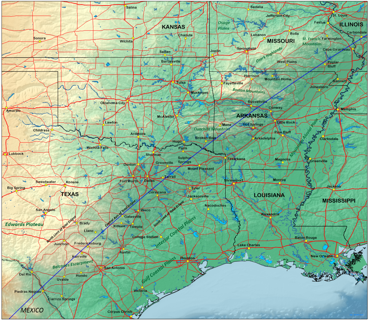
When the Moon’s shadow crosses the Rio Grande and moves into the United States, it traverses the floodplain of the Rio Grande River where elevations are between 200 and 300 m above sea level (please see the topographical map at right). Immediately afterward, the shadow meets the Balcones Escarpment and rises up onto the Edwards Plateau, an increase of about 400 m in elevation. After passing San Antonio and Austin, the track descends onto the Gulf Coastal Plain and later, the Mississippi floodplain, passing Dallas and Fort Worth on its way to the Oklahoma and Arkansas borders.
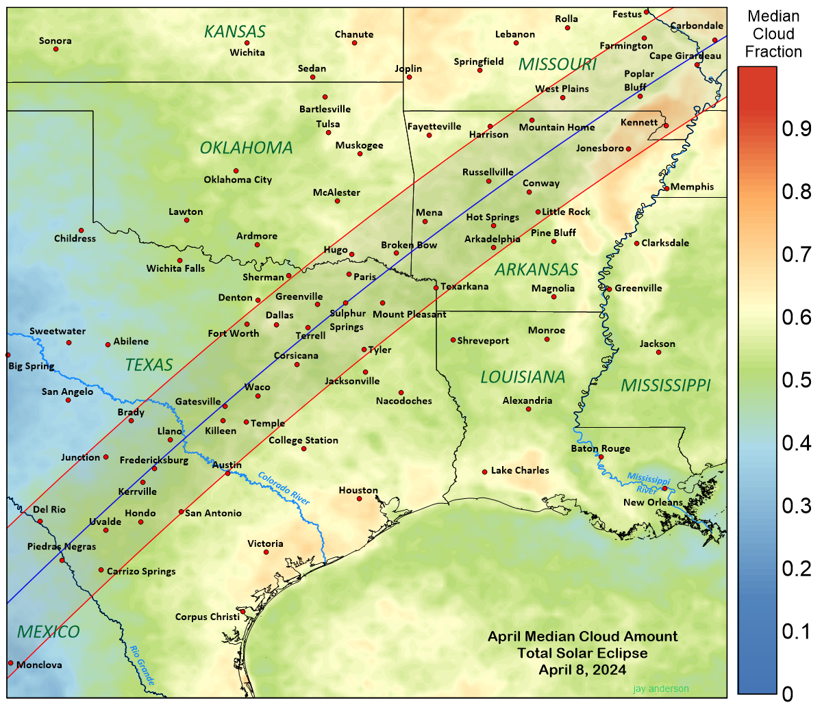
One of the surprises of the graph of centerline cloud cover in is the seeming lack of strong responses to the topography beneath the shadow track, even though there are some significant mountain heights to cross in Arkansas and Missouri. Usually, we expect to see an increase in gloomy weather when the terrain rises and a lower amount of cloud where the terrain descends, but in Texas, where the high plains derive part of their climatology from the Southwestern Deserts, this relationship does not hold. For this part of the eclipse, the centerline cloudiness responds only weakly to the underlying along-track topology.
However, when we look at the map of cloud cover (please see the April Media Cloud Amount graphic at left), we see that there are significant terrain-induced modifications to the cloud cover, but they are off to the north or south side of the central line.
Across Texas, the north side of the track has a notably sunnier April climate than the south. The best of Texas weather prospects—in fact, the best prospects in the United States and Canada—lies on the Edwards Plateau, where median cloud amounts are as much as 15 percent lower than those south of the centre line on the Coastal Plain. We can be even more specific: according to the satellite data, the best climatological prospects lie between Junction and Brady, both in Texas. Brady is perilously close to the north limit but Junction, 28 km inside the track, has an eclipse duration of 3m 7s, generous, but significantly shorter than the 4m 26s at the centerline near Kerrville. Satellite measurements show an median April cloud fraction of 39 percent (0.39 on the map) in the area. Junction is connected with Kerrville and San Antonio by Interstate 10, which provides a convenient cross-track route to better weather from those locations if movement is necessary on eclipse day. Don’t leave it to the last minute—the 2017 eclipse taught us that even Interstates will come to a halt when the eclipse is imminent!
If you have any questions about this event, please contact Club President David Swinney.