Big Bend National Park (October 21, 2022 through October 28, 2022)
Big Bend In Detail Deck | Planning Your Trip | Itinerary Summary | Lodging | Getting There | Planned Excursions | Friends of Big Bend NP Facebook Group
Things To Do | Maps and Books | Photography | Night Photography | Videos | Essential Tips | Club Member Tips
"Whatever you hear about Big Bend not being of National Park stature, please discount it. It is one of the grandest places I have seen, and has a magical mood that, in my mind, puts it among the top really great areas."
-- Ansel Adams to Francis Farquhar, February 16, 1947
This year's Plano Photography Club fall field trip will take us to one of the most remote and striking areas of the great state of Texas - the Big Bend.
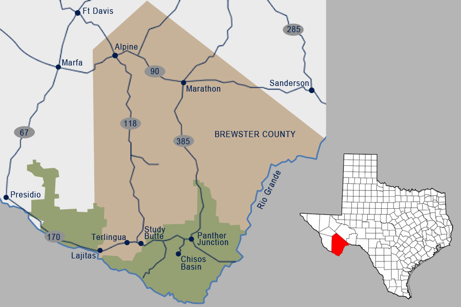
This region is named for the vast curve of the Rio Grande in remote southwest Texas. It is a wildly beautiful natural region, with a complex and fascinating history.
Over one million acres of public land including Big Bend National Park and Big Bend Ranch State Park offer hiking, camping, river running, horse riding, mountain bicycling, birding, jeep touring, and abundant sightseeing and photography opportunities on paved and improved roads.
IT'S NOT TOO EARLY to make hotel reservations (especially if you want to stay within Big Bend National Park) for this fall's big trip.
Planning Your Visit To Big Bend
Lodging
Big Bend is home to a few remarkable communities: Marathon, Study Butte, Terlingua Ghost Town, Lajitas, and Big Bend National Park. Communities offer services, amenities, and entertainment. Accommodations run the range from convenient and comfortable to resort luxury.
You are responsible for obtaining your own lodging; here are some suggestions on where to stay:
Chisos Mountains Lodge
Big Bend National Park has only one lodge/hotel within its boundaries, Chisos Mountains Lodge. There are three developed campgrounds and many backroad campsites available as well.
NOTE: The lodge is already booked as of mid-June 2022, but we recommend that you keep checking for cancellations as the date of our trip gets closer.
The Chisos Mountains Lodge, operated by Forever Resorts, Inc., is nestled within the Chisos Basin at 5,400 feet elevation. The lodge offers a variety of rooms and cottages, plus a gift shop, camper store, and dining room. The lodge is open year-round, and is the only lodging available within Big Bend National Park.
Marathon
Marathon is the eastern gateway to Big Bend National Park, about 30 miles north of the northernmost Park entrance. It offers many choices of accommodation styles: from comfortable roadside hotel, to Santa Fe style luxury, to private adobe casitas.
Study Butte
Terlingua Business District and Study Butte are small communities clustered near the Junction of Highways TX 118 and FM170 a few miles from the western entrance of Big Bend National Park. There are several comfortable accommodations very convenient to the western entrance of Big Bend National Park.
Terlingua Ghostown
Historic Terlingua offers some unique accommodation and camping options. Go historic or go modern, all within walking distance of restaurants for all three meals. Also enjoy a choice of bars, all with great views of the Chisos Mountains and Big Bend National Park.
Lajitas Resort
Lajitas Resort overlooks the legendary Rio Grande and is nestled between the crown jewelry of scenic Texas: Big Bend National Park and Big Bend Ranch State Park.
Outlying Areas
Find peace, quiet and privacy off the beaten path (sometimes well off) even during busy seasons. All within striking distance of Big Bend National Park.
Getting There
Major Routes To Big Bend
There are three major routes to drive from the Dallas-Fort Worth area to Big Bend. You can choose to take the fast way or choose a more roundabout scenic route.
- The fastest route is to take I-20 about 350 miles to Odessa, then follow the directions to Big Bend from Odessa.
- It is almost as fast, and perhaps more interesting, to go west on I-20 to Abilene, then take US 277 south to San Angelo, followed by US 67 to Fort Stockton. US 67 merges with I-10 east of Ft. Stockton. As you hit the eastern limits of Fort Stockton, look for the US 385 exit to Big Bend National Park. For the fastest way to the National Park and Park Headquarters, follow US 385 south for about 55 miles until you hit US 90. Turn east (right) one half mile, and US 385 takes off to the left and continues to Park Entrance. The lovely town of Marathon is a mile east on US 90 (last chance for gas, food, etc.) if you are going straight to the Park. From the turnoff, the Park entrance is 30 miles, and headquarters another 39. Note: Park speed limit is 45 except where slower. Be aware for wildlife as well as drivers distracted by the animals.
The quickest way to the west side of Big Bend National Park, including Terlingua, Study Butte, Lajitas, Santa Elena Canyon, and River Road is through Alpine. Follow US 67 / I-10 through Ft. Stockton for 9 miles to the Alpine exit. Head south (left) on US 67 for about 50 miles. Veer right 8 miles to Alpine. Enter Alpine; right after you pass Sul Ross State University, the road divides. Go about two blocks, take a left on TX 118. Go 80 miles to Terlingua Junction. Take a right on TX 170 for Terlingua, Lajitas, and Big Bend Ranch State Park and River Road. From the Junction, keep going straight on TX 118 for 3 miles for the Big Bend National Park entrance.
- Another route from DFW to Big Bend is to take US 67 all the way through Stephenville, Brownwood, and San Angelo, then pick up the route described above in example “B.”
By taking different routes to and from Big Bend, you can see lots of Texas.
-- Source: VisitBigBend.com
Plan Your Own Route
Plan your route to Big Bend with this free online service which does not require registration. Perhaps you can discover alternate routes with more interesting stops along the way.
If your home city is not listed below, just click on any of these links and change the starting point.
Top Trips to Big Bend National Park from:
- Athens, Texas
- Carrollton, Texas
- Dallas, Texas
- Denton, Texas
- Fort Worth, Texas
- Frisco, Texas
- Garland, Texas
- Lewisville, Texas
- McKinney, Texas
- Plano, Texas
- Richardson, Texas
- Wylie, Texas
-- Source: TopTrips.com
Other Road Trip Planning Tools
Planned Excursions
- Monday, October 24
- 8:45 AM - Meet in Terlingua at Barton Warnock Visitor Center (21800 FM170, Terlingua | map); arrive early to carpool if desired
- Drive first to Crow Town (map) [45 minutes; 1.9 miles past the Hoodoos and Balanced Rock Trail; turn right; Caution: Sandy when dry and may be muddy when wet] and then we work our way back
- Main stop is Closed Canyon (a wonderful slot canyon) (trailhead | Brochure (PDF))
- Bring water and snacks
- Check your gas gauge
- Limited restroom facilities; the detailed presentation shows locations; bring toilet paper
- Bring personal hygiene items
- Wednesday, October 26
- 1:30 PM (approximate) - Informal lunch gathering at Chisos Mountains Lodge Restaurant (1 Basin Road Station, Big Bend National Park | map) (service is spotty and limited; operating hours are 1 PM to 7 PM; takeout is available for the patio)
- 3:00 PM - Meet at the Lost Mine Trail Trailhead (pull out near the end of the road into Chisos Basin | map)
- Parking is limited and carpooling is strongly suggested
- Bring water
- NOTE: This is an informal gathering and not a group hike *
* Comments from Dennis Fritsche:: "People should just take off when they get there and meet on the trail. I only go part way up to what I call the saddle. The path up is from the Basin, when you get to the saddle, you have long views into Mexico and back to the basin. This is an easy route but with elevation gain but not steep - you might huff and puff a bit. If you go all the way up, expect a strenuous climb the last bit. Always bring plenty of water wherever you go."
NOTE: For those who want to hang in the Basin, sunset (7:11 PM) through the window from the short Window View Trail (map) is worthwhile if the weather cooperates.
General recommendations from Janice Goetz: "Having enough water is imperative. Put some cough drops in your pockets. They really help when your throat dries out as a result of breathing through your mouth. I use my tripod as a hiking stick and am extremely thankful to have it. I did get a blister on my hand, so I may bring my thin photography gloves to prevent that. I would add a few Band-Aids to those cough drops. Also had blisters on my feet!"
Things To Do and Places To See
Maps and Books
Big Bend National Park Maps
Big Bend Park Brochure Map
Official park map from the brochure (700 kb jpeg)
Big Bend Area Map
Depicts primary highways near Big Bend (200 kb jpeg)
Chisos Basin and Rio Grande Village Developed Area Map
Detail maps of the Chisos Basin and Rio Grande Village developed areas, showing the location of visitor centers, trailheads, campgrounds, and other facilities.
Chisos Mountains Trails and Campsite Map
Map of the Chisos Mountains trail system with campsites and trail mileages.
Topographic Maps, Trail Guides, River Guides, Road Guides
Topographic maps
Download free topo maps of Big Bend National Park. Use the adjoining 7.5 minute quadrangle legend to navigate and locate the Texas maps you need.
Chisos Mountains Trails Map
Revised in 2019 and in full color, this handy map includes a new inset map of the Chisos Basin Trailhead and developed area as well as descriptions and updated mileage for all trails in the Chisos Mountains: Lost Mine, Pinnacles, South Rim, Emory Peak, Colima, Blue Creek Canyon, Juniper Canyon and Window.
2019 Trails Illustrated Map: Big Bend National Park
This map offers unmatched detail of the entire park including such key areas of interest as Black Gap Wildlife Management Area, Sierra del Carmen, Sierra del Caballo Muerto, and portions of Big Bend Ranch State Park. The print map features detail of the Chisos Mountains, Rio Grande Village, and Burro Mesa.
River Guide to the Rio Grande: Colorado and Santa Elena Canyons
This guide covers from Tapado Canyon to the Santa Elena Canyon takeout and includes Colorado Canyon and Santa Elena Canyon.
River Guide to the Rio Grande: Mariscal and Boquillas Canyons
Newly revised version of the classic guide, with updated text and new full color maps and photos.
River Guide to the Rio Grande: The Lower Canyons
The Lower Canyons of the Rio Grande run 83 miles from the put-in at Heath Canyon Ranch to the take-out at Dryden Crossing.
Guidebooks
Hiking Big Bend National Park
This is the Big Bend National Park entry in the extensive Falcon Guides series.
The Big Bend Guide: Top 10 Travel Tips, Top 10 Hikes, and Top Itineraries for the Casual Visitor - Allan C. Kimball
This is a very small book, literally, on Big Bend National Park. Despite its small size, it offers a lot of good information.
Enjoying Big Bend National Park: A Friendly Guide to Adventures for Everyone - Gary Clark
Probably the best general guidebook to Big Bend National Park; it features lots of general information, and has ideas and activities for those of all ages and fitness levels.
Naturalist's Big Bend: An Introduction to the Trees and Shrubs, Wildflowers, Cacti, Mammals, Birds, Reptiles and Amphibians, Fish, and Insects - Roland H. Wauer
An excellent guide to all of the wildlife and plant life of Big Bend National Park; it was written by the former chief naturalist of the park, and offers a wealth of great information.
Big Bend National Park
Very nice hardcover photo book featuring Big Bend National Park; it showcases the work of Laurence Parent, who also wrote the Falcon hiking guide listed above.
Photographing Big Bend National Park: A Friendly Guide to Great Images - Kathy Adams Clark
A great companion for the photographer visiting Big Bend National Park.
Photography and Big Bend
Photo Galleries
Photo Tips
Stargazing
Night Photography Resources and Tools
These were discussed in Anita Oakley's August presentation on Night Photography.
- Internet Search Queries - Use these sample queries to start your planning for the best Milky Way photo spots; adjust the search terms as needed.
- Dark Sky Finder - Mobile app that helps you locate nearby dark skies to take a telescope, watch a meteor shower, or simply relax under the stars. See light pollution maps of the entire world, along with dots to indicate good observing locations. Each dark site includes reviews, directions, information, Clear Sky Charts, and more.
- PhotoPills - Mobile app to assist you in planning your photography adventure. It helps you PLAN your photos ahead of time so you’re always at the right place at the right time to capture the best photo possible.
- Star Walk 2 - Mobile app that lets you see the real-time interactive sky map on the screen of your phone and enjoy stars, planets, and constellations.
Submitting Your Images
We would love to include your best images from activities in a gallery on the club website and as part of a slideshow at a future monthly club meeting. Photos can be submitted for this purpose by following these guidelines:
- Email 5-7 images from the Big Bend National Park field trip to clubphotos@planophotographyclub.com .
- Include your name and the name of the event in your image file names (e.g., JamesEvans_BigBend_1.jpg).
- The maximum dimension (long edge) for submitted images is 4096 pixels; the maximum file size is 10MB.
- You may need to divide your images and send them in multiple emails if the total size exceeds the maximum size allowed for a single email message.
Videos About Big Bend
Essential Tips
Get Informed
There are many online resources for visiting the region (including many linked from this web page). Read up on the area before you embark on your adventure. There is a lot of area to cover, and it is unreasonable to try and see everything in one trip. Online resources can give you advice on what to see and try and do on your trip.
Plan Ahead and Provide Backups
Big Bend is known for being remote and rugged. Because of this, your trip may not go as planned. Unforeseen things can happen and leave you stranded or worse. Plan your trip around activities and lodging, and prepare alternative activities, routes, lodging locations just in case something should go wrong.
Bring Appropriate Supplies
It is important to be prepared, but bringing a truckload of gadgets is inadvisable. Besides adding weight to hiking or boating trips, gadgets distract from the natural beauty and scenery that surrounds the visitor in this remote region. So, bring only what you need, cell phone, plenty of water, camping and survival gear, and leave the rest up to the local outfitters.
Food and Water
Bring more water than you think you will need. Eat and drink enough throughout your hike to replace the calories and fluid your body is using. Fluid/electrolyte loss can exceed 2 quarts per hour if you hike uphill in direct sunlight during the hottest time of the day. Even on those comfortable winter days the warm, dry desert will leave you dehydrated. One gallon per person per day is the minimum recommendation.
There are small shops for food at the Chisos Basin, Castolon and Rio Grande Village visitors centers. Other than those few options, you will not find any fast food, restaurants or other dining options. Be sure to bring meals and snacks for your trip.
Road Conditions
Know what your vehicle can handle. Although most of the main highlights of Big Bend can be enjoyed from two-wheel-drive cars on paved roads, the park also features miles of more challenging roads. These roads typically require four-wheel-drive (not all-wheel-drive) and vehicles with at least 10 inches of clearance.
Gasoline
There is only one gas station inside the park (just west of the Panther Junction Visitors Center). You will pay more for gas in this remote location, so if you are able, fill up in Terlingua or Marathon.
That being said, you will be driving a lot and there are not many gas options. Do not run out of gas inside Big Bend National Park!
Cell Service and WiFi
Like most national parks, there is no cell service or WiFi inside the park. But unlike other National Parks, there is no service even in the surrounding area and cities outside the park.
Have your maps downloaded well before you get to the area. Plan on not connecting to work or email or social media. You will be off the grid while visiting Big Bend National Park.
Club Member Tips
Lodging
"If anyone stays in Terlingua, Big Bend Resorts is the most reasonable but it's not well maintained. If someone stays at BBR they should get a room with a kitchenette which means it has a microwave oven.
There is a grocery store in Terlingua just down the road a short distance from BBR. When I was there the BBR cafe was closed for dinner. The same company that runs the Big Bend Chisos Mountain Lodge runs Big Bend Resorts." -- Wayne Coltrane
Roads
"There are roads in Big Bend that will accommodate two-wheel drive vehicles, but serious explorers will need four-wheel drive.
The Big Bend Ranch State Park has NO paved roads in the park and most roads require four-wheel drive. I haven't used this Jeep rental site but I will be checking it out for my next Big Bend trip: Rental Jeeps." -- Wayne Coltrane
If you have any questions about this event, please contact Club President David Swinney.